

Today, we are excited to announce that Multicoin led an $8M strategic acquisition of GEOD, the native token of the Geodnet Network, from the Geodnet Foundation.
Geodnet is a precise positioning network that leverages DePIN economics to power mission-critical localization services for drones, autonomous vehicles, and the tens of millions of robots that will likely proliferate the Earth over coming years.
Physical AI is Coming
In Blade Runner 2049, we saw visions of a world where androids lived among humans as co-contributors to the economy and society. In 2025, our robots are much less human-like, but specialized machines have quietly interwoven themselves into every aspect of modern life.
Language models are commoditizing intelligence, unlocking new creative capabilities and transforming knowledge work. But AI isn’t just about text, images, and videos. The evolution of AI is happening in the physical world, and robots are the next frontier.
As AI models become more powerful, their ability to reason about and interact with the physical environment will expand dramatically. This shift will unlock new classes of autonomous systems—from self-driving cars and humanoid robots to drones and industrial automation—that operate with unprecedented intelligence and autonomy.
For these robots to function, they need to answer a fundamental question: Where am I?
As tens of millions of autonomous and semi-autonomous devices are deployed, they all face the same challenge: spatial awareness. Drones executing deliveries, autonomous vehicles navigating dense urban environments, and agricultural machines executing precision planting all require sub-centimeter positioning accuracy to function safely and efficiently.
To achieve this level of precision, these systems rely on sensor fusion, combining multiple localization methods. LiDAR provides high-resolution depth mapping but struggles in fog or rain (it is also heavy, battery-hungry, and expensive). RADAR offers robust distance measurement but lacks fine-grain precision. Vision-based SLAM enables real-time mapping but deteriorates in low-visibility environments. Each of these approaches has limitations, and no single system is foolproof. In the universe of localization approaches, GNSS based positioning with corrections using RTK (Real-Time Kinematics) base stations are considered to be among the most reliable inputs.
Standard GNSS positioning is inherently inaccurate due to atmospheric interference and multipath errors, which results in deviations of 5-10 meters. RTK solves this by using fixed base stations that compare satellite signals to a known location and transmit real-time correction data. This method achieves centimeter-level accuracy—a key unlock for physical AI applications. Most major robotics and automation companies integrate RTK into their systems: DJI for high-precision drones, John Deere for self-driving tractors, Tesla for autonomous vehicles, and Boston Dynamics for industrial inspection robots.
Source: GNSS Store
A problem with RTK today is cost. Building and maintaining RTK base stations is capital-intensive, and requires a substantial investment in hardware, site acquisition, maintenance, and more. Traditional providers like Trimble, Hexagon, and Topcon set up these base stations themselves, and charge customers thousands of dollars per tracked device, limiting accessibility and deployment speed. Coverage is often concentrated in profitable regions, leaving gaps where high-precision positioning is still unavailable.
Inverting the Cost Structure Through DePIN
We have written extensively about how token-incentivized, contributor-owned DePINs structurally invert the cost structure of global, hardware-heavy networks. Geodnet, the largest precision positioning network in the world, is leveraging those principles to incentivize independent operators to install RTK base stations and contribute corrections data in exchange for token rewards.
By shifting the cost burden from a single operator to a distributed network, Geodnet is capable of deploying production-grade RTK stations at a fraction of the cost of traditional providers — specifically by removing the two largest costs from building a network: land and labor. Accordingly, Geodnet is positioned to expand coverage faster, ensure redundancy, and deliver more reliable GNSS corrections than incumbents.
The result is a globally distributed network that scales organically with equivalent quality of service, while simultaneously reducing prices for end users.
Geodnet started scaling aggressively last year. The network expanded from 1.4K base stations in November 2022 to 7.8K stations in June 2024, and, as of January 2025, has more than 13K base stations across 4,377 cities and more than 142 countries.
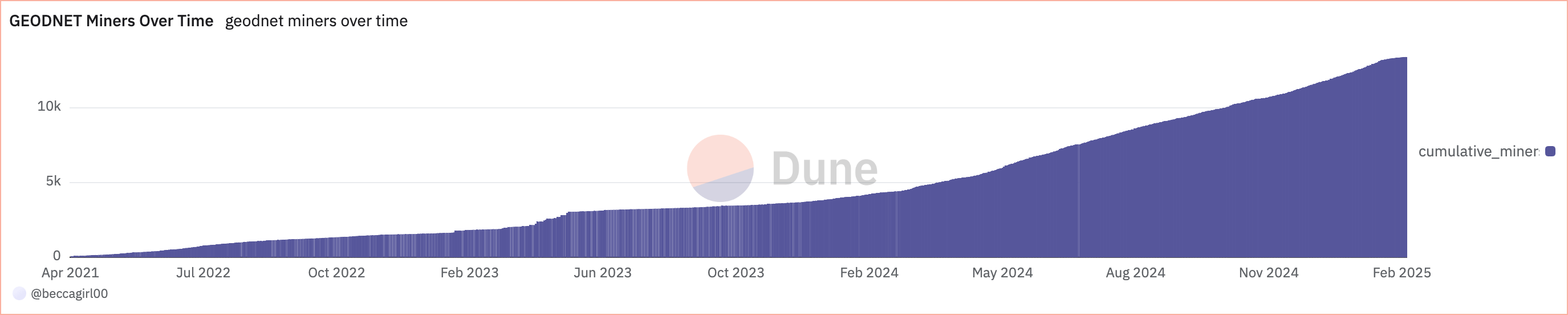
Source: Dune Analytics
The network has achieved “threshold scale,” with a footprint capable of servicing more than 60% of the addressable GNSS corrections market. Notably, the network acquired this supply in an extremely capital efficient manner — only 11% of total tokens have been emitted to contributors over the past three years.
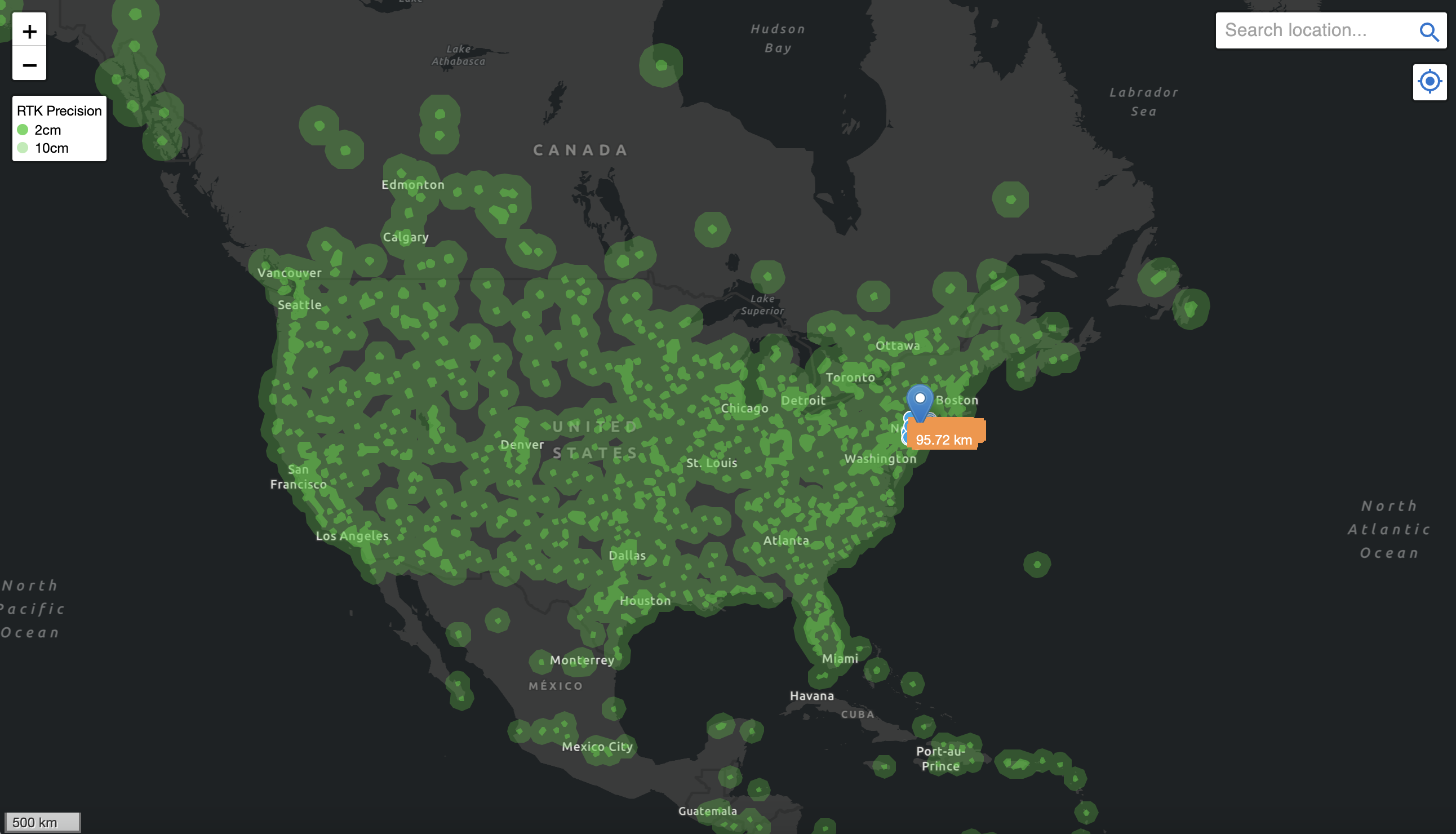
Source: Geodnet Console
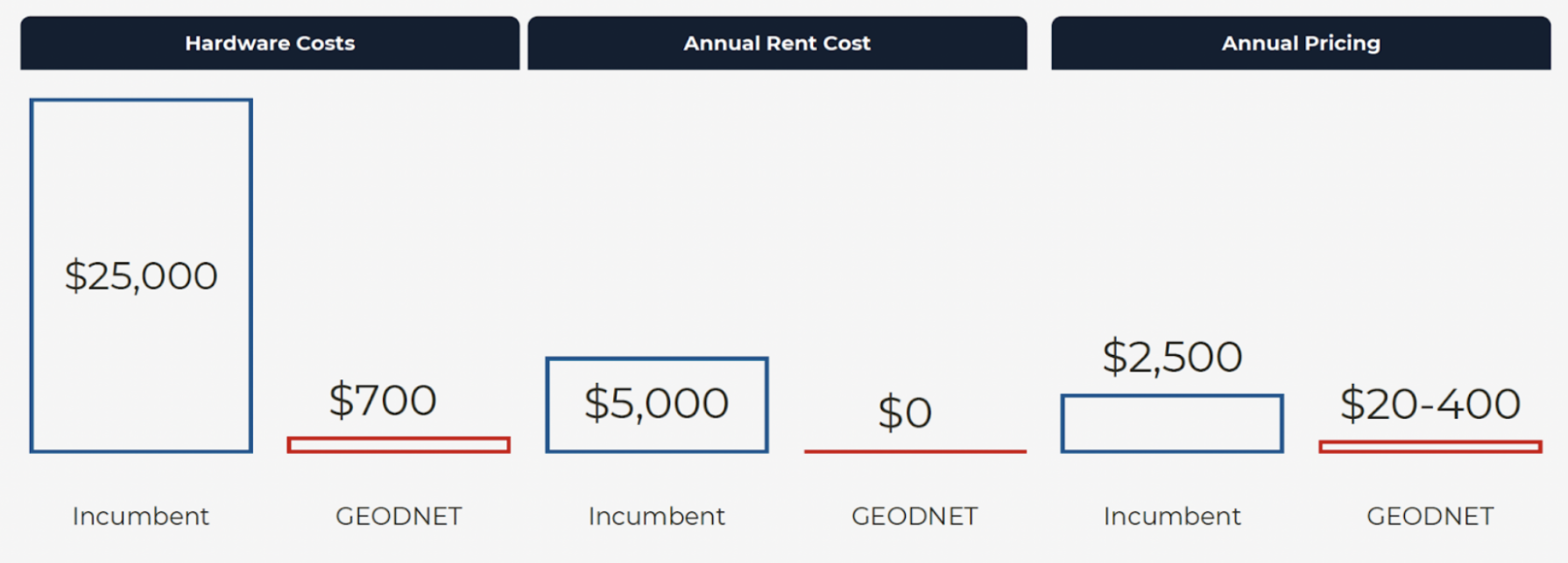
Geodnet is among the canonical examples of the DePIN model working in practice, not just in theory. Not only are Geodnet stations an order of magnitude cheaper (i.e., $700 consumer miner vs. $12K enterprise grade RTK station; denser deployments on the consumer network create equivalent coverage to enterprise RTK stations) to purchase and deploy, annual pricing is an order of magnitude less expensive as a direct result of foregone hardware deployment costs. Geodnet is unequivocally the most scalable and cost-competitive positioning solution on the planet today.
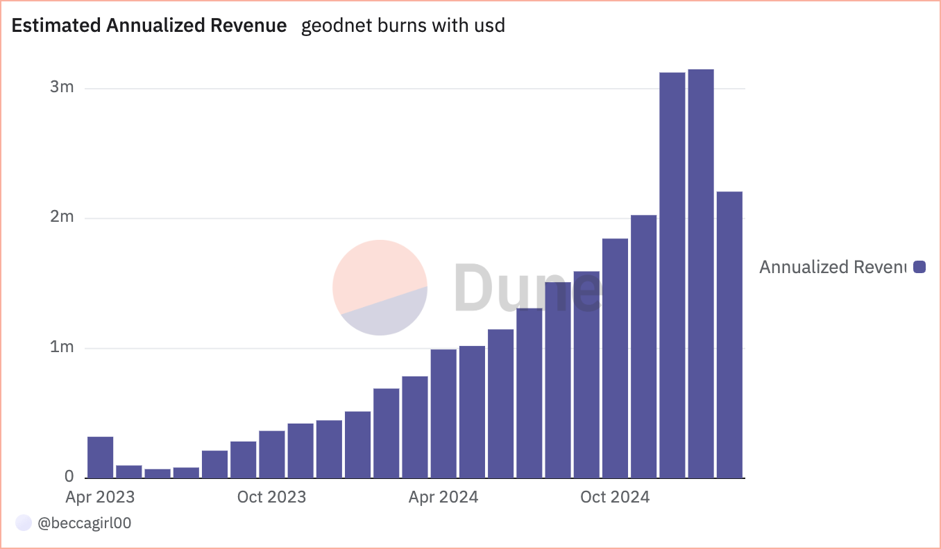
At roughly $3M annualized onchain revenue — generated from enterprise grade service agreements for customers like Propeller, DroneDeploy, Quectel, USDA — Geodnet has among the fastest-growing demand-side revenue profiles among DePINs today.
In our early conversations with Mike Horton, founder of Geodnet, we pressed him on how he was able to secure customers as large as some of the most prominent autonomous vehicles, drones, and agricultural robotics customers on the planet. His answer has always been singular: the core structural cost arbitrage enabled by DePIN.
Inflection Points
Over the next decade, tens of millions of robots will likely be deployed across industries, transforming logistics, infrastructure, and automation. Drones will conduct real-time inspections of power lines and pipelines. Autonomous vehicles will improve freight transport and ride-hailing services. Warehouses will reduce dependence on human labor with purpose-specific machines. Households will have humanoid robots that help with daily chores.
Without reliable positioning data, none of these robots will be able to operate. Self-driving cars will require RTK-enhanced GNSS to navigate dense urban areas where GPS alone fails. Drones will need precise localization to land accurately on charging stations. We believe that RTK positioning is not just complementary to other sensor modalities like LiDAR and RADAR, it is mission critical.
Many robotics companies pay millions annually for legacy GNSS correction services that are expensive, limited in coverage, and inconsistent in accuracy. We believe Geodnet is delivering a more cost effective and higher quality product purpose built for those customers today, and thousands more tomorrow.
The explosion of AI-driven robotics isn’t a question of if, it’s a question of when. Where are all the robots? They’re coming fast — with Geodnet, we’ll know exactly where they are.


